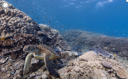
A cool fact that I found as recent news on the Great Barrier Reef. Google Earth has now started taking panoramic pictures underwater of the Great Barrier Reef. Its almost like you have been given a free vacation.
Recently Google has gone to extensive effort to expand the street view of their google earth program. Part of that means going underwater to photograph and film parts of the ocean. It is not only a great idea but also a great learning tool.
Now people around the world can become familiar with one of the most beautiful places on the planet. Most movies and documentaries portray, only the most beautiful parts of the Reef, but now people can have a more palpable portrayal of what the Reef actually is.
Click on the Image to see the article directly from google.
 RSS Feed